
The Old Man of Storr
GPX file from Walkhighlands; file is copyright Walkhighlands and must not be publicly shared on other websites. Do not remove this notice.
- Distance : 5,1 Km
- Dénivelé positif : 335 m
- Altitude maximum : 493 m
- Dénivelé négatif : 335 m
- Altitude minimum : 169 m
Carte interactive de l'itinéraire
Profil de l'itinéraire
- Distance : 5,1 Km
- Dénivelé positif : 335 m
- Altitude maximum : 493 m
- Dénivelé négatif : 335 m
- Altitude minimum : 169 m
À propos de cet itinéraire
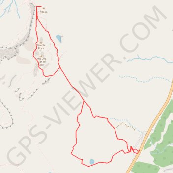
Nom : Itinéraire The Old Man of Storr, distance, dénivelé, altitude, carte, profil, trace GPS
Départ : A855, Staffin, Highland, Écosse, IV51 9HX, Royaume-Uni (57.49830 -6.15838)
Arrivée : A855, Staffin, Highland, Écosse, IV51 9HX, Royaume-Uni (57.49846 -6.15815)
Coordonnées : 57.49699 -6.17600 57.51140 -6.15815
Autres itinéraires de randonnée, VTT, course à pied et activités de plein air
Cliquez sur un itinéraire pour afficher ses statistiques, sa carte et son profil.
Skye Trail
Royaume-Uni > Écosse > Highland > Kilmaluag > Shulista
Distance : 127,4 Km • Dénivelé positif : 3 959 m • Altitude maximum : 655 m
The Storr - ascent
Royaume-Uni > Écosse > Highland
GPX file from Walkhighlands; file is copyright Walkhighlands and must not be publicly shared on other websites. Do not remove this notice.
Distance : 7,9 Km • Dénivelé positif : 569 m • Altitude maximum : 708 m